
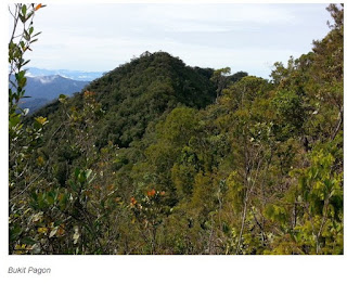
Bukit Pagon (4° 18′ 0″ N, 115° 20′ 0″ E), Brunei’s highest mountain at a height of 1850m is located on the boundary between Brunei and Limbang in the State of Sarawak. This is the southern part of the Temburong District. Mt. Pagon is only accessible by 4x4wd via logging roads crisscrossing mountain range from the Sarawak side, commencing form the small town of Limbang. Once you have passed through the logged area, the scenry opens up and the true beauty of the rain forest is revealed. The journey through to the Base Camp takes approximately 4 hours, dependant on the weather and the state of the logging roads.
Mount Pagon is only accessible by 4×4 WD via logging roads criss crossing mountain range from the Sarawak side,commencing from the small town of Limbang.Once you have passed through the logged area, the scenery opens up and the true beauty of the rainforest is revealed.The journey through to the Base Camp takes approximately 4 hours,dependant on the weather and the state of the logging roads.The lower undisturbed rainforest consists mainly of hardwoods of the Dipterocarpaceae family (two-winged fruits), with a transformation into montane and mosses forest as you climb up the steep path. The pitcher plant species Nepenthes lowii( also known as pitcher plant or monkey cup)can be found on the slope of this mountain.
The lower undisturbed rain forest consists mainly of hardwoods of the Dipterocarpaceae family, with a transformation into montane and mosses forest as you climb up the steep path. The pitcher plant species Nepenthes lowii can be found on the slopes of this mountain. The alternative is to fly in by helicopter. A helipad had been built on Mt Retak in a former expedition. However, there is very little published data resulting from past expeditions although lots of specimens are deposited with the Sungei Liang Forestry Department Herbarium.
Research Potential
Watershed Management – important water catchment for most rivers in Temburong.
Ecotourism research – can serve as a self financing mechanism; tool for conservation. Level, type, and management of tourism appropriate with regards to carrying capacity.
Wildlife studies – with disturbances in adjacent area in Sarawak, will become increasingly a refuge for wild animals.
Carbon sequestration – Green lung, carbon sink for surrounding areas. Ideal area for establishing a tropical rainforest research project focusing on carbon sequestration.
Gene bank/research – Vast biodiversity at Bukit Pagon, possible gene bank for rehabilitation.
Bioprospecting – vast biodiversity which means large number of medicinal plants.
http://www.icubeconsortium.org/index.php/site-administrator/presentations/87-expedition/70-expedition-mount-pagon


No comments:
Post a Comment